Check Your Code NewsBlog

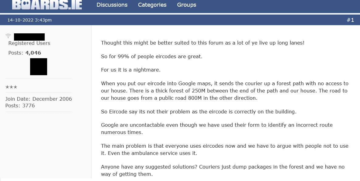 Misrouting of vehicles, including ambulances and 1st responders, by Eircode has been reported for many years now. New examples keep being reported through social media and that means there are many more that go unreported. The above image is from a post a few days ago in boards.ie and is just one more of many many examples. Those who report Eircode mis-routing in relation to deliveries do not always realise that the very same could happen if an ambulance is trying to find them........ ;- but with potentially life and death related consequences. Even though Eircode & the Department of Communications promote their product through Public Service Announcements (PSA's) on RTE for ambulance emergency response, they continue to fail to take any responsibility when a misrouting report raises the possibility of an ambulance being led astray and delayed. They also have taken no steps to warn the public about this well documented issue. Eircode misrouting is predictable and can be avoided. It is explained in detail in our post here -/> We are aware that in previous cases Capita personnel have advised those reporting the issue to contact Google Maps to get them to help solve the problem (not always possible or timely). Not only have they not admitted that by simply moving the location of the Eircode themselves they could resolve the problem, they also fail to advise those with the problem that even if they get the problem solved in Google Maps, the issue may well remain for ambulances as they use a different mapping system (CoPilot - Trimble Maps). Furthermore, other service providers may be using Garmin/Navigon, TomTom or other navigation/map systems which all would have to be contacted to fully (though possibly temporarily) correct a problem which Eircode created and could solve themselves. Unfortunately, Eircode will not do as required to resolve the matter as the An Post design specifications for Eircode limit what the code can point to. The quickest solution for those experiencing Eircode mis-routing is to generate a Loc8 Code for the access to the desired property using the web-app here -/> Then create a sign with the Loc8 Code on it and place for all to see - guidelines for displaying Eircodes or Loc8 Codes are here -/> It is important to understand that the National Ambulance Service has fully integrated Loc8 Code into their systems side-by-side with Eircode since 2017. 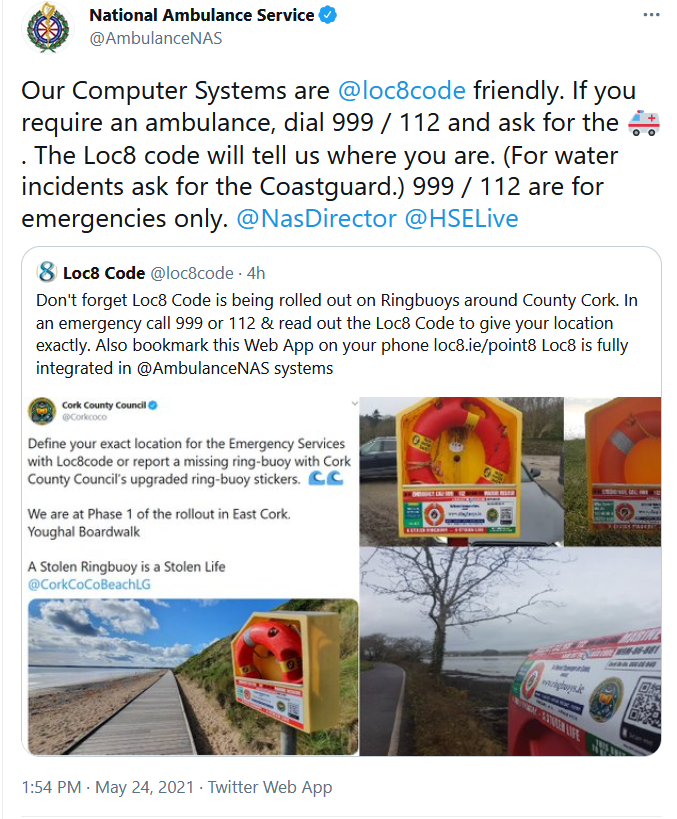 If you are reading this post, please #checkyourcode , advise others to do so also and please do it for those who can't. We are very happy to help and you can make contact with us here -/> 19/9/2022 Fixing Eircode Misrouting in Google Maps May not Fix the Problem for the Ambulance Service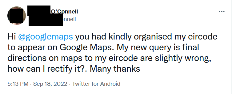 Evidence of Eircode misrouting continues and neither the Dept of Communications nor Eircode (Capita) are warning the Public about it. We know that people who notice that their Eircode is not in Google Maps are being told by Eircode to contact Google themselves. People are not being told to check for misrouting and our last post shows that at least one person received an admission from an advisor to Minister Hildegarde Naughton that Eircode can have problems (misrouting) when used in navigation systems but, again, their advice is to contact the mapping or navigation company yourself to sort it out. We have already highlighted how this is an abdication of responsibility by those responsible for Eircode so let's leave that for now. What is more important to highlight is that if you manage to solve misrouting in Google Maps by communicating with Google itself, that DOES NOT address the possibility of misrouting for the Ambulance Service. The Ambulance Service uses the "CoPilot" navigation system in its data terminals in response vehicles. This DOES NOT use Google Maps. It instead uses Trimble Maps. So if a misrouting issue exists in that, then it will remain. You can try contact Trimble Maps here -/> Of course, logistics companies and other 1st responders may well use other solutions using other mapping systems which would all have to be contacted individually to try ensure nobody trying to find your property is led astray by Eircode induced misrouting. It is important to understand that not everyone uses Google Maps and that professionals whose work involves road navigation very often have dedicated systems suitable for their differing needs. Furthermore, this does not take into account that there may be several different access points to your location with only one appropriate for different service providers or at different times of the day. Contacting all the mapping companies in the world will never resolve this. The only solution would be to be able to move the location of an Eircode so that it can positively identify the required access point. However, the rules enforced by An Post over the use of Eircode prevent that from happening. It should also be noted that even if you do make contact with every mapping company and they agree to help, it can take time (months) for them to apply corrections, then to disseminate them in their databases, then for navigation companies to apply updates and then for the user to ensure their product is updated as well. Meanwhile, those serving you will still be misrouted whilst all that is going on. An immediate solution is to use a Loc8 Code which can be placed just inside the desired access from the nearest mapped public road and no matter what mapping is used, the service provider or emergency responder will always be guided to the correct access point. If there is any ambiguity at that point then the property owner simply has to put up a sign confirming arrival at the correct Eircode or Loc8 Code or Property name and perhaps adding a directional arrow to the sign if required to guide the way to the final destination. Property occupiers do have to take some responsibility in that regard. You can generate a Loc8 Code for any location at this link and, after clicking on the desired spot and generating a Loc8 Code, by pressing the "Route" option you can also prove that the routing will guide to the right location. Loc8 Code is fully integrated into the response systems of the National Ambulance Service side-by-side with Eircode. Loc8 Code offers a FREE WebApp which can be used on multiple devices. In summary, please do not assume that if you manage to solve misrouting in Google Maps that that is the end of misrouting issues. The problem may still remain for Ambulances, other emergency responders and others trying to get to you. However, at least if you are aware of the problem you have some chance of resolving it. It remains that fact, though, that many are not aware because they have not been warned by those behind Eircode. All of the Department of Communications, their Minister and Eircode (Capita) know that the problem exists but to date have chosen not to warn the public to check their code for misrouting or other issues. |