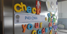
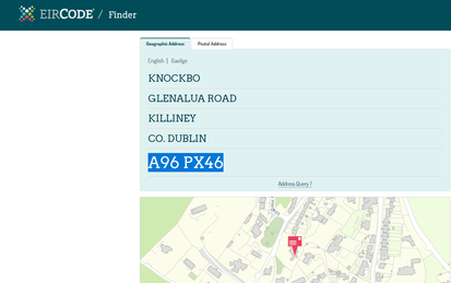
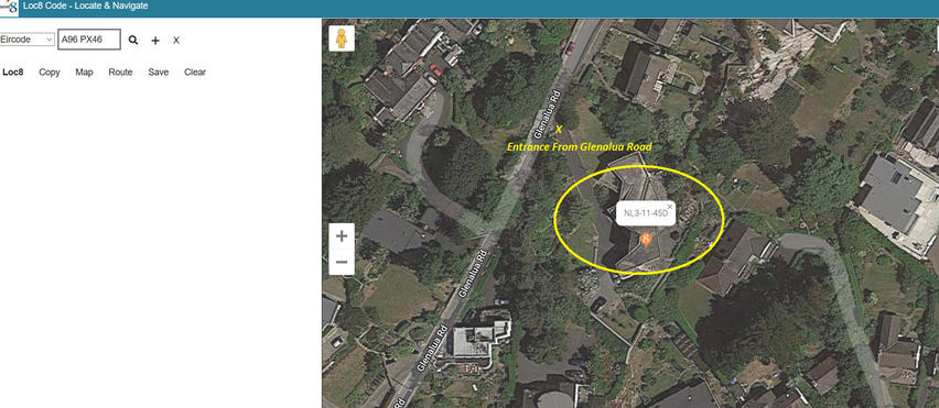
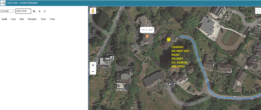
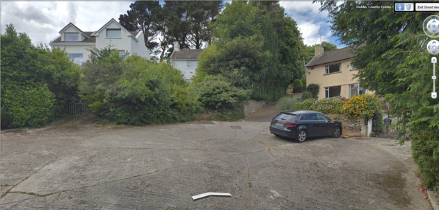
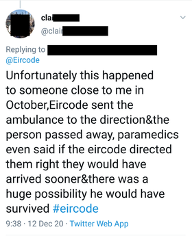
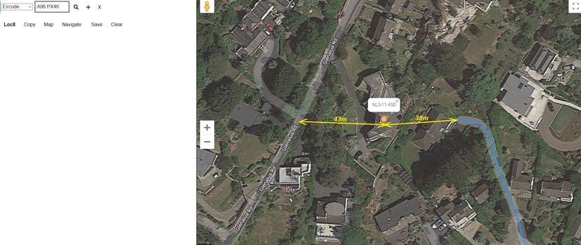
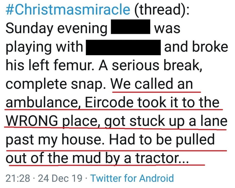
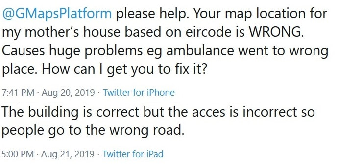
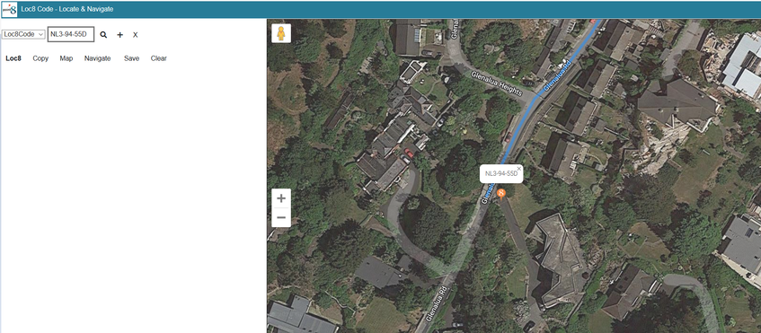
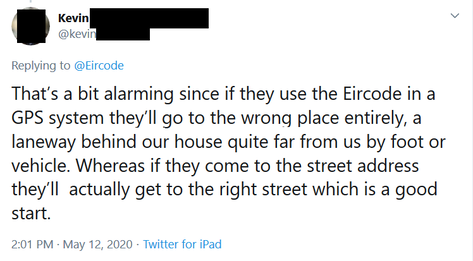
As mis-routing of ambulances by Eircode can put patients' lives at risk, it is important to understand & warn about it Firstly, to understand this issue, you must understand that electronic navigation systems will route to a point on the suitably mapped road nearest to the location of the chosen destination. This is the case for ALL electronic navigation systems whether using Google Maps, Apple Maps, Here Maps in Garmin devices or any other maps in any other electronic navigation systems. Those who are experienced in Navigation & Satellite Navigation (SatNav) will be familiar with this issue which is well understood for many years. It is not a new phenomenon and it existed well before Eircode was conceived. The example we will take from Eircode Finder is as follows: As many people are familiar with Google Maps, lets look at it there but we are going to use the Loc8 Code point8 app so we can show how Eircode mis-routing can be easily solved using a Loc8 Code. Loc8 Code is fully supported by the National Ambulance Service (NAS) side by side with Eircode. The app also allows you to easily check for mis-routing with your Eircode. To do this yourself go to www.loc8.ie/point8, use the drop down box at the top left to select the Eircode option & then enter Eircode A96 PX46 to see the location on the map as shown below:- From the satellite imagery you will note that the entrance to the property is as marked with the yellow "X" on Glenalua Road;- Glenalua Road being part of the postal address for the property. If your device has identified your own location, then you can now click on the "Route" menu option on the point8 app. You will see a blue line showing the route to the East (Right) of the property. You can zoom out to see more of the proposed route. You are only interested in the last few hundred metres or so. You will note that the proposed route brings you to a different property, with a different Eircode, a different address and with access from a different road. So, in this case, an ambulance (or CFR) would be routed to the wrong property, approximately 600m along the road from the correct address. This would also be the case for anyone else trying to find the property, and it maybe the reason if parcel deliveries are being dropped at the wrong house. Looking at the map from overhead, as we are, it is of course easy to spot the issue and then resolve it. However, put yourself in the position of paramedics in an ambulance trying to get to a patient on a dark Irish winter's night. Their destination has been sent by Control to their Data Terminal (Communications, GPS, Mapping & Navigation). Their focus is on getting to the destination to administer medical assistance and they mostly are not aware of the potential for this mis-routing to happen or what causes it. In daylight, this next image is what they would be looking at as they approach;- a cluster of houses with an instruction from their navigation device that their destination is close ahead or that they have already arrived, but neither is the case. At night time, there would be very little illumination, confusion as there is no one to meet them and a reticence to knock on doors because of the late hour. There is no direct connection between this location & the patient's property. The automatic assumption is that either the Eircode was wrong or there is a map error. What follows next, is a series of calls to ambulance control, calls to the the patient (if conscious or if there is someone with the patient) and, eventually & hopefully, verbal directions to the correct house. The ambulance will have been delayed with associated risk to the patient. This example is in an urban area, but if in a rural area at night the mis-routing & delay could be more significant and a life could be at risk as is suggested in the tweet below (unrelated to our Eircode example) from a member of the public just a few weeks ago. What caused this Eircode mis-routing? As stated earlier, all navigation systems will provide a routing solution to the point on the suitably mapped road nearest to the location of the selected destination point. In the case of Eircode P46 PX46, that point on the nearest suitably mapped road is 38metres away;- thereby causing a routing solution via a different property, a different address and a different road from which there is no access. Whilst, this example is being presented to you using Google Maps, the issue would be same in other electronic map/navigation systems if they have the same mapped road features. Most are very much the same nowadays but with some variations. This is an issue well known to those who are experienced in electronic navigation and it is something that an expert in the field would have ensured was addressed in designing a modern postcode system. As Eircode was designed without the involvement of consultants with navigation expertise and without consideration of navigation design requirements in the design document published in May 2014 by Capita PLC, the design does not take into consideration how this known issue could be resolved. In fact, neither the contract for Eircode nor the design specification mentions either navigation or emergency response (ambulances or other) and, therefore, there was no responsibility on those involved to consider the related requirements. Autoaddress, which was a contractor involved in the delivery of Eircode, has recognised that Eircode mis-routing does occur but wrongly claims that it cannot affect ambulances. They claim that this is because the Ambulance Service uses Ordnance Survey Mapping. This is only partly true. They do indeed use Ordnance Survey Mapping on their computer systems in their National Control Centre where emergency calls are taken and locations are visualised by operators. However, Ordnance Survey (OS) mapping does not have the "attribute" or "meta" data necessary to help generate electronic routing solutions, so when an ambulance generates routes to Eircode destinations, it is not using OS mapping. Therefore, ambulances are indeed vulnerable to mis-routing as demonstrated in this article. We can only deduce that because Autoaddress personnel are not familiar with navigation technology, they have misunderstood the facts in this case. Furthermore, as the applications of navigation or emergency response were not considered in the design specification for the National Postcode, the locations to be used for each Eircode were taken to be those already in use with An Post's GeoDirectory. GeoDirectory was designed for address and property identification and, therefore, uses locations which point to buildings. When it comes to navigation, access points from roads are often of more interest than the actual location of a building itself. Since Eircode is now mostly used for navigation, this can be considered as a design oversight and, because An Post will not allow the locations from GeoDirectory to be altered, this means that moving the locations used for Eircodes cannot be adopted as a solution. For this reason, Eircode will cause and continue to be susceptible to mis-routing. This issue was identified well before Eircode was rolled out in evidence to an Oireachtas Committee in June 2015. (see Page 14, Para 6.h. & other references in the document) It has also been frequently reported on social media. How can this Eircode mis-routing be resolved? When designing a piece of national infrastructure which has to be used with multiple mapping solutions, by many people with different capabilities and for many applications with multiple design requirements, it has to be as flexible as possible to meet all these needs. However, as stated above, Eircode was not designed either for navigation or emergency response. To redress that issue now there are multiple possibilities. Most would take a long time, would not be practical, may not be applied consistently, could not be done by the public themselves and none would be 100% reliable or satisfactory. However, the National Ambulance Service fully integrated Loc8 Code into its control Mapping and ambulance navigation systems during 2017 so that it is supported since then, side-by-side with Eircode. To be clear about his, Loc8 Code is coded by programmers into the applications that controllers use in National Emergency Operations Centre (NEOC). They do not use external applications for Loc8 Code and have access to the Loc8 coding to implement it in any of the systems they use as required. Unlike Eircode, Loc8 Code can be generated by anyone (including ambulance controllers) for any location so it can be used to generate a location which can be used by an ambulance (or CFR) to avoid Eircode mis-routing where that problem exists. Taking our example of Eircode A96 RX46 and using it again in the point8 app, it is a simple issue to generate a suitable Loc8 Code at the access point, prove it by creating a route, adjust as necessary until mis-routing is avoided and then use that Loc8 Code when calling the ambulance service. By clicking on a location along the driveway just inside the access from the Glenalua Road (a few metres inside), the Loc8 Code NL3-94-55D is easily generated and clicking on the "Route" menu option confirms that the routing solution will bring an ambulance, CFR or any other vehicle, directly to the right road and right access point. This Loc8 Code should be saved and displayed on a sign inside a property for all to access in case of an emergency. It may be necessary also for someone to check & generate the code as shown here for those who are unable to do so themselves. Guidelines for making signs are given here on our site Eircode can make things Worse so warnings to check them MUST be givenSince 2016, Eircode has been regularly broadcasting an advert via RTE advising people to use an Eircode if they are calling an ambulance. They are, therefore, encouraging it's use for life saving. In the case of the Eircode used as an example here (A96 PX46), we have established that mis-routing and associated potential delays for an ambulance are caused. However, if you type the address "Knockbo, Glenalue Road, Killiney, Co Dublin" directly into Google Maps, because the road name is in the address, the navigation solution will bring the user via Glenalua Road very close to the correct access point. Therefore, by using the Eircode, the routing solution is actually made worse;- exactly as highlighted by this member of the public in a tweet last year (unrelated to the example used in this article) This is not only a potential problem for ambulances, it is also a problem for Community First Responders (CFR's) who are encouraged to use Eircode when responding as instructed by the ambulance service. Of course Eircode is a significant benefit and should be used where available & functional but, as this article explains, because of its design it can cause problems and, in some cases, the problems would not exist at all if the original address was used in the first place. For this reason, as there is a potential for Eircode to make things worse than they would be without it, any advertising to encourage its use MUST include warnings that codes should be checked and information about how that can be done should be given. The Public could be directed to the Guide on this website Since it is publicly recognised by by Autoaddress, who were involved in delivering Eircode, that it can cause mis-routing; since there is evidence that Minsters involved have been made aware of the issue and, since there are many examples on social media of both ambulances and other vehicles being mis-routed by Eircode;- the problem and its potential to cause delay in the delivery of critical medical care in some cases cannot be disputed. Furthermore, since the solution to this issue is relatively simple, is already implemented by the ambulance service and can be undertaken by many on their own behalf or for others using Guidelines on this website, it could easily be considered negligent for related warnings not to be publicised. Since the advert states that using an Eircode when calling the National Ambulance Service "May help", it should also state that, as shown in the example used in this article, it may also not help and actually can make things worse. That should also be made clear. Prior to the advent of Eircode, paramedics driving ambulances and CFR's had to deal with addresses and directions. This was a far from perfect system but elements of related procedures ensured that there was a constant awareness of the address, thee route and location. Over reliance on Eircode, without suitable warnings about its limitations, can cause a reduction in situational awareness and those involved should be trained to adjust their practices to compensate for this. Professional training for Navigation with electronic devices has always warned against over-reliance and the need to have an awareness of the full journey plan and locations/landmarks with associated clues on the way. No such training has been delivered to courier or transport drivers using Eircode & it is hoped that paramedics & CFR's are getting related professional support. In the meantime, there is a duty of care for those behind the Eircode ambulance advert currently being broadcast by RTE as a Public Service Announcement (PSA), to take ownership of these issues and ensure that suitable warnings and supporting information are also included. |
|
Search by typing & pressing enter
